Introduction to Google Earth Engine Course using Python
- Teacher: System Admin

- Teacher: System Admin

Introduction and principles of Land administration; Concepts and functions of land administration systems; Land use; Land tenure; Land rights; Cadastral systems; GIS modelling; LIS; Modelling concepts; Cadastral models; Spatio-temporal models; Data handling technologies; Person, land rights and objects; Geodetic systems; projection systems; Georeferencing and transformation; GPS; Mobile GIS; 2D digitizing and scanning; cadastral maps; Land policy; Land taxation; Cadastral databases.
- Teacher: System Admin

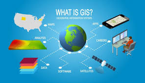
A Geographic Information System, or GIS, is an organized collection of computer hardware, software, geographic data and personnel designed to efficiently capture, store, update, manipulate, analyze and display all forms of geographically referenced information.
- Teacher: System Admin
